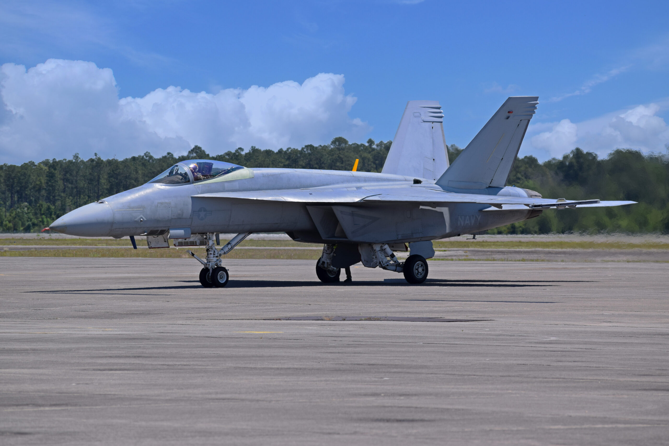
Morocco is the 17th country to acquire the Boeing AH-64 Apache through a contract for 24 of the helicopters that was recently signed.
Boeing has delivered nearly 2,500 Apache helicopters to 16 nations to date, including the U.S., Netherlands, Greece, United Kingdom, Japan, India, Singapore, South Korea and Saudi Arabia. Deliveries to Morocco are expected to begin in 2024.
“This is another step forward in our long partnership with the Kingdom of Morocco,” said Jeff Shockey, vice president, Global Sales and Marketing, Boeing Defense, Space & Security and Government Services. “Worldwide demand for the Apache is growing and we are proud to provide this best-in-class capability to Morocco.”
The AH-64E Apache is the latest configuration of the attack helicopter. It is designed and equipped with an open systems architecture including the latest communications, navigation, sensor and weapon systems. It has an improved Modernized Target Acquisition Designation System that provides day, night and all-weather target information, as well as night vision navigation capability. In addition to classifying ground and air targets, the Fire Control Radar has been updated to operate in a maritime environment.
Boeing will build and deliver the new Moroccan Apaches under a contract with the U.S. Army through the U.S. government’s Foreign Military Sales process.
Boeing’s partnership with Morocco spans decades. The company is committed to developing Morocco’s supply chain and future workforce. Boeing is a partner of the MATIS Aerospace joint venture, which produces airplane wire bundles and harnesses. In 2016, the company signed a Memorandum of Understanding with the Kingdom to create an ecosystem of aircraft equipment suppliers. Boeing also supports the country’s future workforce through partnerships with Education for Employment (EFE) Morocco and the INJAZ Al-Maghrib association.
Currently traveling at some 105 million kilometres from Earth, the Airbus-built Solar Orbiter (SolO) is en route for an encounter to uncover the secrets of our closest star.
While humankind has been studying the Sun for hundreds of years, the research is limited because data was always collected from distances more or less equal to the star’s separation from Earth, according to Ian Walters, Airbus’ SolO Project Manager.
“Solar wind takes about two to four days to get from the Sun to Earth, and in that time, it transforms completely,” he explained. “We can better correlate what is seen with what is felt from the Sun if we can get up close. That’s the point of the Solar Orbiter mission…and it’s never been achieved before.”
Solar Orbiter was launched in February in a joint mission of the European Space Agency and the U.S. National Aeronautics and Space Administration. Travelling closer to the Sun than its nearest planet – Mercury – SolO will make comprehensive measurements of the nascent solar wind.
Beating the heat
For the spacecraft and its 10 instruments to survive extreme temperatures of up to 600 deg. Centigrade, Airbus designed a protective heat shield with openings for SolO’s five telescopes to peek through during the trek.
According to Walters, the most critical heat protection technology is the Stand-off Radiator Assembly (SORA) – a set of radiators sitting on the spacecraft’s side that is always in shadow, enabling them to quickly transfer heat from the instruments into space. SORA’s thermal straps are made from pyrolytic graphite, which is five times more conductive than copper wire but flexible like paper.
To avoid any molecular contamination that could compromise imagery from the telescopes, Airbus also built Solar Orbiter to levels of cleanliness far exceeding any other spacecraft built in the UK to date. Every item on SolO has been heated to over 120 degrees to make sure no gases are emitted in the vacuum of space.
Predicting solar events
Data from Solar Orbiter can help make significant improvements to everyday life, particularly when it comes to predicting solar flares and coronal mass ejections (CME) – the expulsions of plasma and its accompanying magnetic field from the sun, which can have a major impact on Earth.
“In 1859, one such episode took down the world’s telegraph network,” Walters said. “A similar event today would severely disrupt our power grids, mobile phone towers, navigation systems and many other critical technologies.”
He added: “If we could predict the CME was coming our way, we’d have about two days’ notice for emergency government committees to be activated and react, instead of the few minutes’ notice we receive today.”
Super Hornet to become the fourth Boeing platform for the flight demonstration team.
Boeing has modified Blue Angels since 2008 and delivered 23 aircraft to date.
Boeing [NYSE: BA] has delivered the first Super Hornet test aircraft for the U.S. Navy’s Blue Angel flight demonstration squadron. The unpainted aircraft now enters the flight test and evaluation phase at Naval Air Station Patuxent River in Maryland. Boeing expects to deliver a total of 11 aircraft for the squadron in 2020.
“The Super Hornet is an iconic representation of excellence in naval aviation,” said ret. Admiral Pat Walsh, vice president of U.S. Navy & Marine Corps Services for Boeing. Walsh flew with the Blue Angels from 1985 to 1987 as the Left Wingman (#3) and Slot Pilot (#4). “As Boeing continues to support the operational fleet of Navy Super Hornets, we are excited to see this platform enter a critical phase of its journey to joining the team.”
The flight demonstration squadron has flown Boeing or Boeing-heritage aircraft for more than 50 years, starting with the F-4J Phantom II in 1969, and then moving to the A-4F Skyhawk. The team currently operates the F/A-18A-D Hornet.
Boeing converts F/A-18 Hornets and Super Hornets into Blue Angels at the company’s Cecil Field facility in Jacksonville, Florida. Major modifications include the addition of an oil tank for the smoke-generation system, fuel systems that enable the aircraft to fly inverted for extended periods of time, civilian-compatible navigation equipment, cameras and adjustments for the aircraft’s center of gravity.
Boeing is the world’s largest aerospace company and leading provider of commercial airplanes, defense, space and security systems, and global services. As a top U.S. exporter, the company supports commercial and government customers in more than 150 countries. Building on a legacy of aerospace leadership, Boeing continues to lead in technology and innovation, deliver for its customers and invest in its people and future growth.
The Airbus built BepiColombo mission will make a fly-by past Earth on 10th April 2020 as it continues on its epic journey to Mercury.
The joint European Space Agency and Japanese Space Agency spacecraft will swing past Earth at about 13,000 km away, closer than navigation satellites (GPS, Galileo). It will be BepiColombo’s final glimpse of Earth before it continues on its seven year, 8.5 billion kilometre journey to the Solar System’s innermost, smallest and least explored planet, Mercury. The last time the spacecraft saw Earth was 18 months ago in October 2018, when it was launched on an Ariane 5.
BepiColombo is not due to arrive at Mercury until 05th December 2025, but to get there safely and at the right speed to be captured by Mercury’s gravity, it must do nine flybys of the inner planets, one past Earth, two at Venus and six flybys at Mercury. After arrival, the spacecraft will capture data for a year with the possibility of extending the mission.
BepiColombo will collect measurements to study the composition, geophysics, atmosphere, magnetosphere and history of Mercury as well as testing Einstein’s theory of general relativity. The 16 scientific instruments will also provide insights into the characteristics of Mercury’s magnetic field and how it interacts with the solar wind.
Philippe Pham, Head of Earth Observation, Navigation and Science said: “This flyby marks a great achievement and major milestone for Airbus. Teams across five countries worked together to successfully develop and launch the spacecraft on a complex mission to Mercury.”
The journey will total some 8.5 billion km, completing 18 orbits around the Sun before entering the spacecraft’s operational orbit and beginning scientific exploration of the planet Mercury.
Major upgrade adds option to load instrument procedures, customized holds and more
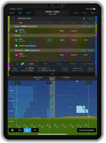
Garmin International, Inc., a unit of Garmin Ltd. (NASDAQ: GRMN), today announced the addition of new features within the Garmin Pilot™ app that incorporate professional IFR navigation tools found within Garmin avionics. Pilots can experience a near-seamless transition between Garmin avionics and the Garmin Pilot app when performing common functions, such as loading and activating instrument approach procedures, departures and arrivals within the Americas. Additional features such as a visual procedure selector, custom holding patterns and more, give pilots convenient access to advanced tools all within a mobile app.
Vertical planning within Garmin Pilot (Photo: Business Wire)
“Leveraging technologies found within Garmin avionics and flight decks, we’re excited to bring this game-changing update to Garmin Pilot customers,” said Carl Wolf, vice president of aviation sales and marketing. “This upgrade gives pilots the ability to load complex routes and procedures into the app just as they would within a Garmin integrated flight deck, offering added convenience, time savings and confidence when transitioning between multiple Garmin products in the cockpit.”
Professional IFR navigation tools
Within the latest Garmin Pilot upgrade, pilots have the option to load or activate departures, arrivals and instrument approach procedures. Published holds that are included as part of the missed approach are also added to the flight plan. When pilots activate a procedure with published altitude constraints, those altitudes are automatically incorporated into a flight plan within the app. Pilots can also choose to manually add altitude constraints into a flight plan. Additionally, approach procedures with radius-to-fix (RF) legs can be activated within Garmin Pilot.
Using the vertical planning feature within Garmin Pilot, pilots can more easily input and adhere to crossing restrictions in a flight plan. For example, pilots can manually input a crossing restriction over a specific navigational aid or GPS waypoint. With these new features, pilots can optimize their flight planning and fuel calculations.
Visual procedure selector
Pilots can now more easily visualize departures, arrivals and instrument approach procedures prior to a flight using the visual procedure selector. This new selector allows pilots to simultaneously view departures, approaches or arrivals on a map alongside a flight plan so it’s easier to visualize and select the most appropriate procedure based on a flight plan and intended direction of flight.
Customized holding procedures
Pilots now have the flexibility to easily build customized holding patterns. These holds may be created over an existing fix or over a user-defined waypoint and then inserted into a flight plan. When creating a hold, pilots can easily input an inbound or outbound course, select left or right turns and specify leg length in time or distance. Unpublished holds or those assigned by air traffic control are easily created and displayed within Garmin Pilot to simplify the process of visualizing and flying a holding pattern.
Worldwide route data packages
Route data packages within Garmin Pilot help to ensure pilots have downloaded all of the data required for a flight plan. Once a flight plan is entered, pilots can review the data that is downloaded to their mobile device. If information is missing for a particular flight, Garmin Pilot displays an option to download additional data. Route data packages are also available worldwide to help ensure pilots have all of the data they need prior to every flight. Databases that are included within the worldwide route data packages include navigation data, instrument approach procedures, SafeTaxi®, terrain, obstacles and more.
The newest release of Garmin Pilot on Apple mobile devices is available immediately. For new customers, Garmin Pilot is available in the Apple App Store as a free download for the first 30 days. After the 30-day trial period, customers may purchase an annual subscription of Garmin Pilot starting at $79.99. Garmin Pilot is supported by Garmin’s award-winning aviation support team, which provides 24/7 worldwide technical and warranty support. Visit www.garmin.com/aviation for additional information.
GTN 650Xi & GTN 750Xi modernize cockpit navigation and are available immediately
OLATHE, Kan.–(BUSINESS WIRE)– Garmin International, Inc., a unit of Garmin Ltd. (NASDAQ: GRMN), today announced the GTN™ 650Xi and GTN 750Xi, the next generation of in-flight navigation technology. Designed as a direct slide-in upgrade to the previous generation GTN 650/750, pilots can preserve their panel and modernize the cockpit with the new GTN 650Xi and GTN 750Xi. The all-in-one GPS/NAV/COMM boasts a feature-rich multifunction display and can integrate with new or existing remote-mount equipment such as a transponder or audio panel. Dual-core processors and modern hardware also prepare the GTN Xi series for advanced capabilities in the future. The GTN 650Xi and GTN 750Xi have received Federal Aviation Administration (FAA) approval and are available immediately for fixed-wing single-engine and multi-engine piston, turbine and experimental aircraft, with helicopter and business aircraft approvals soon to follow.
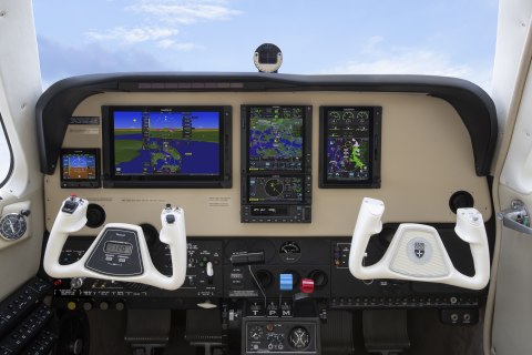
GTN 750Xi and GTN 650Xi in the panel of a Bonanza (Photo: Business Wire)
“After decades of innovation and pioneering the GPS/NAV/COMM, we’re excited to bring the fourth generation GTN 650Xi and GTN 750Xi to the market,” said Carl Wolf, vice president of aviation sales and marketing. “Garmin was the first to introduce the all-in-one navigator with the iconic GNS 430/530. Over time the GNS WAAS and the industry-first GTN 650/750 touchscreen navigators were added to the line-up along with state-of-the-art features such as voice control, wireless connectivity and more. As the leader in GPS cockpit navigation, we have brought the most widely adopted navigators to the industry and with the GTN 650Xi and GTN 750Xi, we’re excited to add one more to the family.”
Modern processing power and state-of-the-art hardware within the GTN 650Xi/750Xi supports faster map rendering and smoother panning throughout the touchscreen navigator. It boasts a large, ultra-high-resolution display and wide viewing angle that offers superior readability in the cockpit. The displays initialize within seconds of start-up, providing immediate access to frequencies and flight plan information, saving valuable time in the aircraft. Preserving the same form factor as the previous generation GTN 650/750, the 6-inch-tall GTN 750Xi and the 2.65-inch-tall GTN 650Xi offer an intuitive touchscreen design with a dedicated direct-to button and dual concentric knob that provide added convenience when interfacing with the display.
Retaining all the features of the GTN 650/750, the GTN Xi series adds a vibrant display and vivid colors that enhance the contemporary look of the new navigators. When installed alongside a G500 TXi or G600 TXi flight display, the GTN Xi series brings a new level of modernization to the cockpit. Highly complementary, the GTN Xi and the TXi flight displays share similarities in display, appearance and hardware qualities. For example, both products feature an angular bezel so the pilot has a near-seamless experience when transitioning between the touchscreen flight display and the navigator.
The GTN 650Xi/750Xi offer advanced navigation functions, including ILS and LPV instrument approach procedures, as well as visual approach guidance. Based on a published glide path angle or a three-degree glideslope from the threshold of the runway, visual approaches also take into account terrain and obstacle clearance to assist pilots in flying a stabilized approach to the runway in visual flight conditions. Approach types that incorporate radius-to-fix (RF) leg types are also supported by the GTN Xi series. Additional capabilities include the option to add a published or custom holding procedure, vertical navigation (VNAV), graphical flight plan editing on the moving map and more.
The colorful, multifunction display-like map allows pilots to better visualize their dynamic position relative to potential hazards, such as terrain, weather and traffic. Geo-referenced instrument approach procedures can be overlaid on the map page, offering superior situational awareness when transitioning from the enroute to approach phase of flight. Terrain alerting is included within the GTN Xi series and further enhances situational awareness by using its internal terrain and obstacle database to provide audible and visual terrain proximity alerts, including, “terrain ahead, pull up” and “obstacle ahead, pull up.” Helicopter Terrain Awareness and Warning System (HTAWS), TAWS-A and TAWS-B are available as options.
Superior integration with an array of avionics on the market make the GTN 650Xi/750Xi a simple and straightforward solution to incorporate into any cockpit. Options for remote audio panel or transponder display and control allow aircraft owners to simplify their panel. When paired with a Garmin autopilot, such as the GFC™ 500 or GFC 600, pilots can fly fully coupled VNAV profiles and instrument approach procedures. Pilot workload-reducing features such as Telligence™ voice control are also available within the GTN Xi when paired with the optional GMA™ 35c. When paired with a GSR 56 Iridium datalink, global text and voice calling can be completed through the touchscreen display on the navigator.
Wireless connectivity is available with the optional Flight Stream 510, allowing pilots to connect their mobile devices running the Garmin Pilot™ and FltPlan Go applications to the GTN 650Xi/750Xi. When connected to the navigator, pilots can save time in the cockpit by wirelessly transferring aviation databases and flight plans from their mobile device to the navigator. Flight Stream 510 also supports the sharing of traffic, weather, GPS position information and more. The GTN Xi series is also compatible with the cost-effective Garmin navigation database.
The GTN 650Xi and GTN 750Xi have received FAA Supplemental Type Certification (STC) and are available immediately through Garmin Authorized Dealers for a suggested retail price of $12,495 and $17,995 respectively. A free GTN Xi trainer app is also available for download on Apple mobile devices, which allows customers to experience the feature set of these navigators. A new GTN Essentials 2.0 eLearning Course provides instruction on best practices for operational use of the new GTN Xi series and can be accessed via this website: https://buy.garmin.com/en-US/US/p/712644. The GTN Xi series come with a two-year warranty and are supported by Garmin’s award-winning aviation support team, which provides 24/7 worldwide technical and warranty support. Garmin was awarded top honors last year in avionics product support for the 16th straight year by Aviation International News,and earned the top spot in the annual avionics product support survey conducted by Professional Pilot magazinethis year, also for the 16th consecutive year.
(Saint-Cloud, October 29, 2019) – This summer, Lann-Bihoué French naval air station received the first two ATL2 maritime patrol aircraft upgraded by Dassault Aviation.
Last week, Florence Parly, Minister of the Armed Forces, flew on one of these aircraft.
These two events demonstrate the progress made on the upgrade program which is designed to modernize the ATL2 combat system to standard 6.
new radar: Thales Search Master with active antenna,
new Thales acoustic subsystem to gather and process signals from the latest-generation air-dropped sonobuoys for submarine detection,
new navigation console designed by Dassault Aviation,
new consoles for the tactical display subsystem, developed by SIAé.
The upgrade work is performed by Dassault Aviation and Thales (co-contractors), in association with Naval Group and in cooperation with SIAé. Architect of the combat system, Dassault Aviation is as well responsible for development of the core system including LOTI software designed by Naval Group. Dassault Aviation is also in charge of overall integration of all subsystems.
All the specifications for this program were established using the PLM Systèmes tool as part of a Dassault Aviation-Thales-Naval Group-SIAé collaborative work platform installed at St-Cloud in the Dassault Aviation design office.
The standard 6 upgrade will improve the ATL2s’ capability to support the Strategic Ocean Force, to deal with modern threats (future nuclear or conventional submarines, naval forces at sea, etc.) and to support air-land missions, until 2030.
France is one of the very few countries producing high-technology maritime patrol aircraft combining detection (optronics, radar, acoustics) with a variety of weapons (anti-ship missiles, torpedoes, laser-guided weapons).
“This expertise as an architect of maritime patrol solutions, both for the platform and for systems integration, is the result of experience dating back to the late 1950s and the launch of the ATL1 program, the predecessor of the ATL2. Dassault Aviation has extended this experience, from the 1970s onwards, with the maritime surveillance Falcons, the latest version of which is the Falcon 2000 MRA-based Albatros program. As we have shown once again with the standard 6, this maritime patrol/maritime surveillance expertise builds largely on the trust and the excellent working relations between our company, the DGA and the French Navy, to which I express my sincere gratitude. We will leverage this know-how to prepare together maritime patrol solutions beyond 2030”, declared Eric Trappier, Chairman and CEO of Dassault Aviation.
OLATHE, Kan.–(BUSINESS WIRE)– Garmin International, Inc., a unit of Garmin Ltd. (NASDAQ: GRMN), today announced certification of the G1000® NXi integrated flight deck upgrade for the King Air C90. With the G1000 NXi, aircraft owners and operators receive a wealth of new features, innovative capabilities and added utility all within a modern flight deck. King Air C90 owners and operators can easily upgrade from the G1000 to the G1000 NXi with minimal aircraft downtime and installation labor to receive a next-generation integrated flight deck.“As the popularity and demand of the G1000 NXi continues to grow, we’re excited to expand the availability of this upgrade to even more aircraft”
“As the popularity and demand of the G1000 NXi continues to grow, we’re excited to expand the availability of this upgrade to even more aircraft,” said Carl Wolf, vice president of aviation sales and marketing. “The G1000 NXi is an advanced flight deck that adds modern features including wireless connectivity, visual approach guidance, SurfaceWatch™, HSI map and more, all of which add tremendous value and advanced capability than ever before into existing King Air C90 aircraft.”
Flight Stream 510 and Connext® technology within the G1000 NXi integrated flight deck enables Database Concierge, the wireless transfer of aviation databases from the Garmin Pilot™ app on a mobile device to the G1000 NXi. Additional features include two-way flight plan transfer, the sharing of traffic1, weather1, GPS information, back-up attitude information and more, between the G1000 NXi and the Garmin Pilot, FltPlan Go and ForeFlight Mobile applications.
Visual approach guidance and map overlay within the horizontal situation indicator (HSI) further enhance the G1000 NXi feature set. Within the HSI map, pilots can overlay NEXRAD, Flight Information Service-Broadcast (FIS-B) weather, weather radar, SafeTaxi® airport diagrams, traffic, terrain and more. NEXRAD weather radar imagery can be overlaid on the moving map and animated on the multifunction display (MFD). Split-screen view is also available on the MFD, offering a simultaneous view of maps, charts, checklists, flight plans and more on a single screen. The addition of sectional charts and IFR low/high enroute charts give pilots convenient access to chart data on the flight display.
The G1000 NXi also supports the display of Automatic Dependent Surveillance-Broadcast (ADS-B) In traffic and subscription-free Flight Information Service-Broadcast (FIS-B) weather. The addition of SurfaceWatch runway monitoring technology provides visual and aural cues to help prevent pilots from taking off or landing on a taxiway, on a runway that is too short or on the wrong runway based on performance data entered during preflight. Visual and audible runway distance remaining annunciations are also available via SurfaceWatch within the G1000 NXi.
Modernized displays offer improved readability, while state-of-the-art processors provide smoother panning throughout the displays and faster map rendering within the G1000 NXi. Because the flight displays initialize in seconds, pilots have immediate access to frequencies, flight plan data and more, saving valuable time in the cockpit. The G1000 NXi integrated flight deck also incorporates contemporary animations and new LED back-lighting, offering increased display brightness and clarity, reduced power consumption, and improved dimming performance.
This upgrade adds to the growing portfolio of aircraft eligible for the G1000 NXi integrated flight deck upgrade, including the King Air 200/300/350, Daher TBM 850/900, Cessna Citation Mustang, the Piper PA-46 and soon, the Embraer Phenom 100. Aircraft owners and operators can easily upgrade to the G1000 NXi with little aircraft down time and disruption of the panel because the displays preserve the same footprint and connectors, so panel and wiring modifications are minimized. The G1000 NXi upgrade for the King Air C90 is available immediately through select Garmin dealers. The upgraded components of the G1000 NXi also come with a two-year warranty, which is supported by Garmin’s award-winning avionics product support team. For additional information regarding the G1000 NXi upgrade for the King Air, contact Scott Frye at 913-440-2412 or scott.frye@garmin.com.
Garmin’s aviation business segment is a leading provider of solutions to OEM, aftermarket, military and government customers. Garmin’s portfolio includes navigation, communication, flight control, hazard avoidance, an expansive suite of ADS-B solutions and other products and services that are known for innovation, reliability, and value. For more information about Garmin’s full line of avionics, go to www.garmin.com/aviation.
The Italian manufacturer will provide ENAV – the Italian air navigation service provider – with the maintenance of the four P.180s used for flight inspection activities at national airports.
Piaggio Aerospace has been awarded a contract for the maintenance of the P.180s owned by ENAV, the company that manages civil air traffic in Italy. The agreement, with an estimated duration of approximately 7 years, is worth 12.6 million euro and will guarantee integrated logistic support for ENAV’s fleet of four P.180 Avanti II.
“The agreement signed represents a further step forward in the turn-around process of Piaggio Aerospace”, commented Vincenzo Nicastro, Extraordinary Commissioner of Piaggio Aerospace. “While strengthening the backlog of the Genoa factory-owned service centre, it also confirms the unique expertise of the company in the airframe MRO domain, consolidated throughout decades of activities”.
The ENAV P.180s perform an average of 1,800 flight hours per year. Thanks to their special equipment, they carry out regular measurements and calibration of airport navaids (Radar, VOR, DME, VDF, ILS etc.) in order to guarantee their continuous operational accuracy, essential for the safety of air navigation.
A similarly equipped P.180 will be showcased at MAKS ’19, the international air show that will be held at Zhukovsky International Airport (Moscow) from August 27 to September 1. A delegation of Piaggio Aerospace will also be present at the air show.