TOMORROWS TRANSPORTATION NEWS TODAY!

Tag: detect

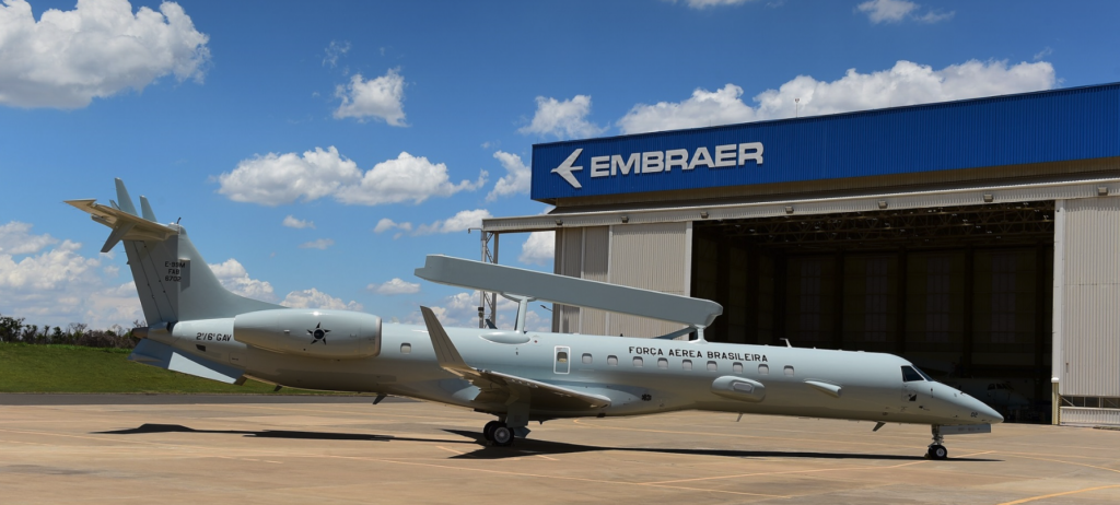
Embraer Delivers First Modernized E-99 Jet to Brazilian Air Force

From Embraer press release

In a ceremony held today at the Embraer facility in Gavião Peixoto (São Paulo, Brazil), Embraer delivered the first modernized EMB 145 AEW&C (Airborne Early Warning and Control), designated E-99, to the Brazilian Air Force (FAB). Four additional E-99 aircraft will be modernized as part of the contract.

The mission systems and related subsystems, including electronic warfare, command and control, electronic countermeasures, and aerial surveillance radar were updated as part of the modernization process, expanding FAB’s capacity to carry out Flight Control and Alarm missions and Electronic Reconnaissance, among others.

The E-99M project is conducted by COPAC with support from Embraer and various international suppliers, such as SAAB, Aeroelectronica International (AELI), and Rohde & Schwarz. In addition to modernization, the project entails technology transfer agreements that will enable technological advancements for the Brazilian defense industry.

Atech, an Embraer Defense and Security company, participates in the development of the command and control system. Six mission planning and analysis stations were also acquired, which will be used for the training and improvement of crews.

Built on the successful ERJ 145 regional jet platform, with more than 1,200 units delivered and 30 million flight hours, the FAB E-99 aircraft can detect, track, and identify targets in their patrol area and transmit this information to allied forces. The aircraft can also perform airspace management, fighter positioning and interception control, signals intelligence, and surveillance missions.

NATO Gives Boeing $1 Billion Deal to Upgrade AWACS Reconnaissance Planes

AWACS part of NATO investment in hi-tech surveillance

Announcement comes days before NATO summit in London

BRUSSELS, Nov 27 (Reuters) – NATO on Wednesday awarded Boeing Co a $1 billion contract to upgrade its fleet of AWACS reconnaissance planes, a deal officials said showed the strength of transatlantic cooperation days before an alliance summit in London.

First flown in 1982 and repeatedly modernised, the Boeing-made planes, which can detect hostile aircraft, missiles, ships and other weaponry far beyond NATO borders, will be overhauled with more powerful computer processors, servers and equipment.

The 14 planes, based at an air base in Germany, can already exchange information via digital data links, with ground-based, sea-based and airborne commanders, but need a greater capacity to transmit data as technology develops.

The upgrade will keep one of the few military assets owned and operated by the Western alliance in service until 2035.

AWACS have been flown in support of the international coalition against Islamic State, gazing deep into Syria from Turkey, as well as along NATO’s eastern flank following Russia’s 2014 annexation of Crimea from Ukraine.

“The modernisation will ensure that NATO remains at the leading edge of technology,” NATO Secretary-General Jens Stoltenberg told a news conference alongside Boeing President Michael Arthur, standing in front of one of the planes.

“It will provide AWACS with sophisticated new communications and networking capabilities, so these aircraft can continue their vital missions,” he said.

One NATO official described AWACS, which have crews drawn from 18 different allies, as a symbol of NATO unity, at a time when U.S. President Donald Trump has questioned its value and French President Emmanuel Macron last month said NATO was dying.

The upgrade will be funded by 16 NATO allies, including the United States, Germany, Turkey, Italy and Spain, and some work will be subcontracted to European suppliers including Leonardo and Airbus.

The modernisation comes as NATO takes delivery of the first of five Global Hawk drones, which will be based in Italy.

After years of delays, the high-altitude drones made by Northrop Grumman give the alliance its own spy drones for the first time and will work with the AWACS to protect ground troops, as well as other tasks.

The drones will be able to fly for up to 30 hours at a time in all weather, providing near real-time surveillance data.

(Reporting by Robin Emmott Editing by Mark Heinrich)

Bangladesh Orders Leonardo High-Tech Air Surveillance Radar

  • Leonardo’s KRONOS family of radar products are multi-functional, multi-mission solutions
     
  • The KRONOS LAND radar is highly mobile and quick to deploy: it can be brought into operation in the field in just 15 minutes

 The Bangladesh Air Force (BAF) has ordered Leonardo’s KRONOS LAND radar to provide air surveillance, allowing operators to detect and track targets in tactical environments. Leonardo has announced the contract at BIDEC (Bahrain International Defence Exhibition and Conference) tri-service exhibition, which is taking place at Manama (Baharain) from 28 to 30 October.

Leonardo will also supply communications equipment, twelve months of technical support services, spare parts and a comprehensive training programme for Bangladeshi Air Force personnel with modules in Italy and Bangladesh. As a complete package, this contract will enable the BAF to develop a long-term maintenance capability and preserve the functionality of the system. 

Completely designed and developed by Leonardo, the KRONOS LAND is a multi-functional, multi-mission 3D radar for air surveillance and defence, based on latest-generation Full Active-Electronically-Scanned-Array (AESA, also known as E-scan) technology. Leonardo has sold more than 40 KRONOS family systems worldwide.

The contract to supply KRONOS LAND to the Bangladesh Air Force bolsters Leonardo’s presence in Bangladesh. It follows the earlier provision of the RAT31 surveillance system to the BAF for early warning and air defence.

Image from leonardocompany.com

Airbus Announces New and Expanded Capability for OceanFinder

Toulouse, 18 September 2019 – Airbus Defence and Space has released the latest version of OceanFinder, its digital maritime service to detect, identify and track collaborative and non-collaborative vessels around the globe.

First launched in 2018, OceanFinder leverages Airbus’ advanced constellation of optical and radar satellites, combined with real-time global Automatic Identification System (AIS) data, and the latest in automated analytics, to support a broad range of critical applications across defence and security, shipping, oil and gas, and insurance markets.

OceanFinder’s latest updates introduce a number of innovative features – extending the service’s capabilities in several key areas. From today, users will benefit from enhanced imagery and AIS data correlation to identify the precise location of a non-responding vessel in near real-time. This development has been combined with the latest in fully-automated detection and classification, which utilises powerful proprietary algorithms to determine a vessel’s identity in just a few seconds. Subsequently, Airbus’ human analysts are able to focus on providing additional, value-added intelligence, such as interpretation of specific behaviour or threats, without delaying a report’s delivery. New tools have also been incorporated to provide the most relevant acquisition plan to predict routes and projected locations of vessels, based on last position, date, trajectory and speed. 

Several of the unique features have been made possible through a multi-year partnership with exactEarth, a leading provider of satellite-AIS data services. The agreement, which provides OceanFinder with access to exactView RT – exactEarth’s second-generation real-time satellite-AIS data platform – includes all live and archived data.

“By combining Airbus’ satellite imagery with the most advanced AIS data services and analytics, we are positioning OceanFinder as a key reference for maritime detection and identification” said François Lombard, Director of the Intelligence Business for Airbus Defence and Space. “Automation and near real-time are the two pillars through which we will provide our customers with the insights they need to make decisions faster, whether for real-time situational awareness, Search and Rescue operations or location and tracking of illegal maritime activities.”

OceanFinder is accessible through the OneAtlas web portal (oneatlas.airbus.com), enabling customers to ‘self-order’ the required products through a simple user interface that is available 24/7.