TOMORROWS TRANSPORTATION NEWS TODAY!

Tag: Identification

Texas Central and Amtrak Seek to Explore High-Speed Rail Service Opportunities

Washington, D.C. – Texas Central Partners (“Texas Central”) and Amtrak are seeking opportunities to advance planning and analysis work associated with the proposed Dallas-Houston 205-mph high-speed rail project to further determine its viability. Amtrak has cooperated with Texas Central on various initiatives since 2016 and the two entities are currently evaluating a potential partnership to further study and potentially advance the project.

The proposed approximately 240-mile route would offer a total travel time of less than 90 minutes between two of the top five major U.S. metropolitan areas and would complement future, new and improved corridor and long-distance service in the southern region.

Texas Central and Amtrak have submitted applications to several federal programs in connection with further study and design work for the potential Dallas to Houston segment, including the Consolidated Rail Infrastructure Safety and Improvements (CRISI) grant program, the Corridor Identification and Development program, and the Federal-State Partnership for Intercity Passenger Rail (FSP-National) grant program.

Amtrak has worked with Texas Central since 2016 when it entered into agreements to provide through-ticketing using the Amtrak reservation system and other support services for the planned high-speed rail line.

In addition to current Amtrak service in Texas and planned station improvements, Amtrak submitted grant applications for daily Sunset Limited service and the extension of the Crescentfrom Mississippi through Louisiana and Texas. Amtrak supports Kansas DOT’s Heartland FlyerExtension Corridor Identification and Development (Corridor ID) application that will connect Wichita and communities across Kansas, Oklahoma, and Texas to the Amtrak network. Amtrak also supports Texas DOT’s applications for the Texas Triangle (Dallas – Fort Worth – Houston – San Antonio) routes.

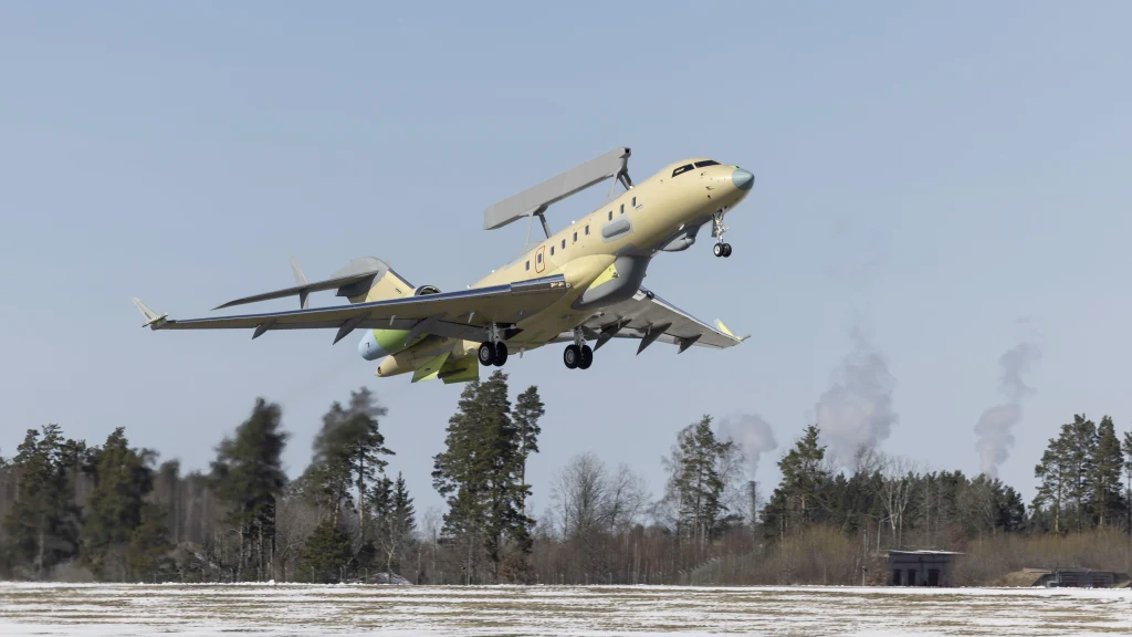
Saab’s Fourth GlobalEye Conducted Successful First Flight

  • The first flight of the fourth GlobalEye is an important milestone in Saab’s Airborne Early Warning & Control (AEW&C) program and highlights that Saab can rapidly and reliably deliver GlobalEye.

The Saab (OTC: SAABF) aircraft took to the skies from Saab’s airfield in Linköping, Sweden on April 03, 2023 and performed several tests related to the aircraft’s capabilities.

GlobalEye is the most modern multi-domain Airborne Early Warning & Control (AEW&C) solution with an array of active and passive sensors that provide long-range detection and identification of objects in air, at sea and over land.

By providing real-time information to units in air forces, armies and navies, GlobalEye enables enhanced situational awareness of the surrounding areas and early detection of threats. It can also be used for non-military tasks such as leading and coordinating rescue missions during natural disasters or larger accidents at sea or on land.

Airbus Announces New and Expanded Capability for OceanFinder

Toulouse, 18 September 2019 – Airbus Defence and Space has released the latest version of OceanFinder, its digital maritime service to detect, identify and track collaborative and non-collaborative vessels around the globe.

First launched in 2018, OceanFinder leverages Airbus’ advanced constellation of optical and radar satellites, combined with real-time global Automatic Identification System (AIS) data, and the latest in automated analytics, to support a broad range of critical applications across defence and security, shipping, oil and gas, and insurance markets.

OceanFinder’s latest updates introduce a number of innovative features – extending the service’s capabilities in several key areas. From today, users will benefit from enhanced imagery and AIS data correlation to identify the precise location of a non-responding vessel in near real-time. This development has been combined with the latest in fully-automated detection and classification, which utilises powerful proprietary algorithms to determine a vessel’s identity in just a few seconds. Subsequently, Airbus’ human analysts are able to focus on providing additional, value-added intelligence, such as interpretation of specific behaviour or threats, without delaying a report’s delivery. New tools have also been incorporated to provide the most relevant acquisition plan to predict routes and projected locations of vessels, based on last position, date, trajectory and speed. 

Several of the unique features have been made possible through a multi-year partnership with exactEarth, a leading provider of satellite-AIS data services. The agreement, which provides OceanFinder with access to exactView RT – exactEarth’s second-generation real-time satellite-AIS data platform – includes all live and archived data.

“By combining Airbus’ satellite imagery with the most advanced AIS data services and analytics, we are positioning OceanFinder as a key reference for maritime detection and identification” said François Lombard, Director of the Intelligence Business for Airbus Defence and Space. “Automation and near real-time are the two pillars through which we will provide our customers with the insights they need to make decisions faster, whether for real-time situational awareness, Search and Rescue operations or location and tracking of illegal maritime activities.”

OceanFinder is accessible through the OneAtlas web portal (oneatlas.airbus.com), enabling customers to ‘self-order’ the required products through a simple user interface that is available 24/7.