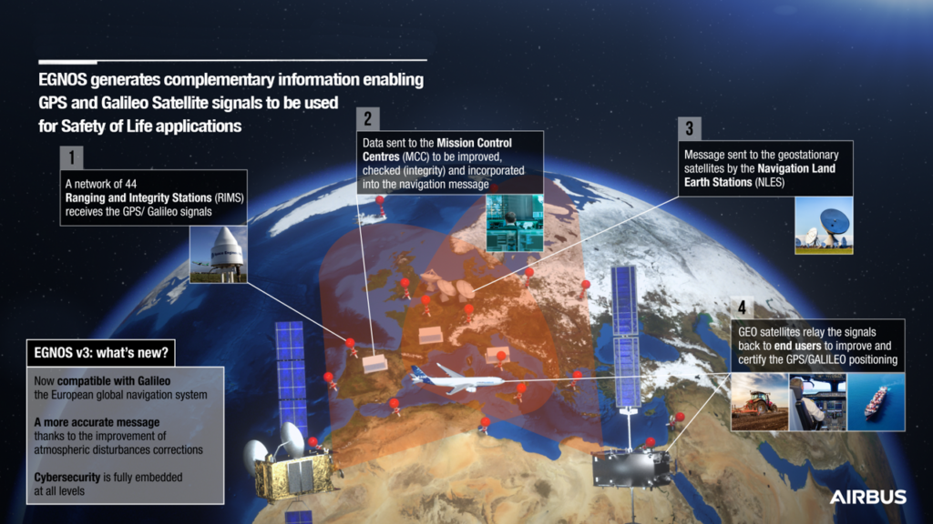

Airbus-led consortiums have recently won a series of contracts to shape the future of EGNOS, the European Geostationary Navigation Overlay Service. EGNOS enhances Galileo and GPS signals to provide augmented safety of life services.
EGNOS V3, set to replace the current version, is already being developed by a consortium of 20 European companies led by Airbus. It will enable ‘Category I’ automatic landing of aircraft – with the flight crew supervising – in weather conditions where it would otherwise be dangerous or impossible to operate.
To prepare EGNOS V3 Evolutions, the European Space Agency (ESA) has awarded a new study contract to Airbus. The focus is on the use of the augmentation service for stringent operations like Category II approach and landing under very low visibility conditions going beyond the current EGNOS V3 performance requirements.
Preceding this, Airbus has been conducting an innovative study under the ESA NAVISP Programme to assess the potential of sensor fusion techniques, for aviation applications demanding stringent performance requirements aiding operations under low visibility conditions. The study assesses the fit and the benefits of this approach to the Positioning Navigation & Timing (PNT) requirement adherence, in particular for the Satellite Navigation.
In addition, Airbus, together with European partners, has won a series of contracts from the European Global Navigation Satellite Systems Agency (GSA) and ESA to extend EGNOS service use for the safe operations of railways. The resulting projects are:
– CLUG (Certifiable Localisation Unit with GNSS): GNSS could prove a game changer for the European railway network by enabling a significant reduction of trackside equipment and by improving localisation performance. This project is performing mission analysis/needs identification and a preliminary feasibility study of an on-board localisation unit.
– GREET (GNSS for the Railway EnvironmEnT) ESA recently awarded Airbus a study for the development of a railway GNSS receiver chain to support the testing and validation of integrity concepts, algorithms, and techniques for receivers in railway environment.
– EGNSS-R (European GNSS for Rail): Rail signaling systems are used to safely control traffic in order to prevent train collisions. The project aims to define a new GNSS augmentation service for improved rail signaling, along with an implementation roadmap.