TOMORROWS TRANSPORTATION NEWS TODAY!

Tag: terrain

Beechcraft Denali Moves Closer to First Flight with Successful Ground Engine Runs

WICHITA, Kansas, August 26, 2021 – Textron Aviation today announced it successfully completed initial ground engine runs on the prototype Beechcraft Denali single-engine turboprop powered by GE Aviation’s new advanced Catalyst engine. The ground engine runs, which took place at Textron Aviation’s west campus in Wichita, Kansas, verified the functionality of the fuel system and engine, as well as the interface with the avionics and electrical systems. The testing moves the clean-sheet design aircraft closer to its milestone first flight, which is anticipated by the end of the year.

The Beechcraft Denali is designed and manufactured by Textron Aviation, a Textron Incorporated (NYSE: TXT) company.

Watch the new Beechcraft Denali video!

GE Aviation’ Catalyst engine has completed over 2,450 hours of testing and is prepping for a first flight on its Beechcraft King Air flying test bed. The Catalyst engine is a more environmentally friendly engine that burns less fuel than older turboprop technologies. The engine can also use sustainable aviation fuel, which results in lower emissions. The 1,300 shaft horsepower (SHP)-rated turboprop engine eases pilot workload with its single-lever power and propeller control. The Full Authority Digital Engine Controlled (FADEC) engine provides trend monitoring, which allows for on-condition maintenance with no mid-life Hot Section Inspection required.

The Beechcraft Denali development program has achieved several important milestones in recent months. Earlier this summer, GE Aviation Catalyst engine was installed on the Beechcraft Denali prototype airframe and the aircraft was powered on for the first time. Two other Denali flight test articles are also in development. Three additional ground test articles will be used for the airframe static and fatigue tests, and for cabin interior development and testing. The company anticipates certification for the Denali in 2023.

Technological advances
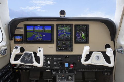
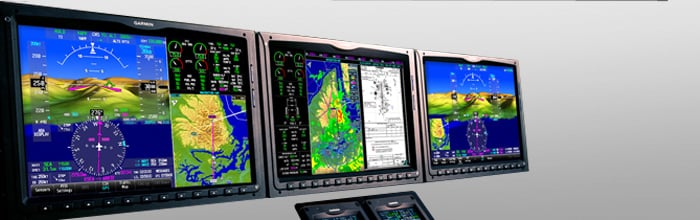
The Denali cockpit features the Garmin (NASDAQ: GRMN) G3000 intuitive avionics suite featuring high-resolution screens and touchscreen controllers. An integrated Garmin autothrottle is now a standard feature, which interfaces with the Automatic Flight Control System (AFCS) and Flight Management System (FMS) to provide easy speed control throughout all regimes of flight from takeoff to touchdown.

Other standard G3000 features include a 10-inch weather radar, Terrain Awareness Warning System (TAWS-B), and dual transponders with automatic dependent surveillance-broadcast (ADS-B) capabilities, which are compliant with the latest air traffic control requirements.

the Garmin G3000 intuitive avionics suite

The aircraft is equipped with McCauley’s new 105-inch diameter composite, 5-blade, constant speed propeller, which is full feathering with reversible pitch and ice protection. The propeller will undergo a series of certification tests, and several are already underway.

Class-leading passenger experience
The Beechcraft Denali’s flat floor cabin is designed to be the largest in its segment and offers the versatility to easily convert between passenger and cargo configurations. The Denali cabin features a standard seating configuration of six individual reclining seats and offers a nine-place high density seating option.

The aircraft boasts a digital pressurization system maintaining a 6,000-foot cabin altitude at a service ceiling of 30,000 feet. The Denali also offers passengers the convenience of adjusting the cabin temperature and airflow from a climate-control switch panel located on the cabin sidewall.

Denali customers will also enjoy large cabin windows, interior LED lighting, a forward refreshment cabinet and an in-flight accessible baggage compartment. An optional externally serviceable belted lavatory with pocket door enclosure that is located in the rear of the cabin is also available.

Swiss Army Chooses Lockheed Martin’s Indago 3 UAS For Tactical Reconnaissance And Surveillance

Armasuisse contracted Lockheed Martin (LMT) for a fleet of Indago 3 small unmanned aircraft systems (UAS), with options for spares, training and tech support and additional systems for the Swiss Army.

Indago provides aerial reconnaissance in environments unreachable by normal fixed-wing, unmanned aircraft systems.

The first phase comprises manufacturing development to optimize the Indago 3’s configuration to meet Swiss Army requirements. These include:

  • Integration of a transponder for sense and avoid;
  • Installation of the Silvus Technologies’ radio; and
  • Implementation of Lockheed Martin CDL Systems’ VCSi Touch SUAS Ground Control System software that includes access to Swiss maps, including digital terrain elevation data (DTED), and Geofencing.

The first set of optimized systems will be delivered later this year with the remaining systems to be delivered several months following the first delivery. These Indago 3s will support tactical level reconnaissance and surveillance to support information collection, search and rescue, disaster relief and battle damage assessment.

“Indago 3 is uniquely qualified to support the Swiss Army’s mission needs,” said Steve Fortson, UAS Portfolio manager at Lockheed Martin. “Indagos operate very quietly from relatively low altitude and provide high fidelity sensor imagery. They are simple to use and require minimal training so soldiers can quickly execute their mission. The Silvus Technologies radios also deliver best-in-class performance and efficiency in a miniature package. They’re ideal for use in portable and embedded applications where size, weight, power and cost are key.”

Depending on payloads and operating environment, Indago 3 has a flight time of up to 50 minutes, a range of 10 kilometers, a cruise speed of 25 knots and dash at up to 40 knots. It can also operate at temperatures as low as 30-degrees below zero and as high as 120 degrees Fahrenheit. It’s cyber-secure with high fidelity color and infrared 3-axis stabilized sensors – and at approximately 5 lbs., Indago can be easily transported by a single backpack and deployed in less than three minutes.

Garmin Brings Flight Deck Tools to the Garmin Pilot App

  • Major upgrade adds option to load instrument procedures, customized holds and more

Garmin International, Inc., a unit of Garmin Ltd. (NASDAQ: GRMN), today announced the addition of new features within the Garmin Pilot™ app that incorporate professional IFR navigation tools found within Garmin avionics. Pilots can experience a near-seamless transition between Garmin avionics and the Garmin Pilot app when performing common functions, such as loading and activating instrument approach procedures, departures and arrivals within the Americas. Additional features such as a visual procedure selector, custom holding patterns and more, give pilots convenient access to advanced tools all within a mobile app.

This press release features multimedia. View the full release here: https://www.businesswire.com/news/home/20200218005216/en/

Vertical planning within Garmin Pilot (Photo: Business Wire)

Vertical planning within Garmin Pilot (Photo: Business Wire)

“Leveraging technologies found within Garmin avionics and flight decks, we’re excited to bring this game-changing update to Garmin Pilot customers,” said Carl Wolf, vice president of aviation sales and marketing. “This upgrade gives pilots the ability to load complex routes and procedures into the app just as they would within a Garmin integrated flight deck, offering added convenience, time savings and confidence when transitioning between multiple Garmin products in the cockpit.”

Professional IFR navigation tools

Within the latest Garmin Pilot upgrade, pilots have the option to load or activate departures, arrivals and instrument approach procedures. Published holds that are included as part of the missed approach are also added to the flight plan. When pilots activate a procedure with published altitude constraints, those altitudes are automatically incorporated into a flight plan within the app. Pilots can also choose to manually add altitude constraints into a flight plan. Additionally, approach procedures with radius-to-fix (RF) legs can be activated within Garmin Pilot.

Using the vertical planning feature within Garmin Pilot, pilots can more easily input and adhere to crossing restrictions in a flight plan. For example, pilots can manually input a crossing restriction over a specific navigational aid or GPS waypoint. With these new features, pilots can optimize their flight planning and fuel calculations.

Visual procedure selector 

Pilots can now more easily visualize departures, arrivals and instrument approach procedures prior to a flight using the visual procedure selector. This new selector allows pilots to simultaneously view departures, approaches or arrivals on a map alongside a flight plan so it’s easier to visualize and select the most appropriate procedure based on a flight plan and intended direction of flight.

Customized holding procedures

Pilots now have the flexibility to easily build customized holding patterns. These holds may be created over an existing fix or over a user-defined waypoint and then inserted into a flight plan. When creating a hold, pilots can easily input an inbound or outbound course, select left or right turns and specify leg length in time or distance. Unpublished holds or those assigned by air traffic control are easily created and displayed within Garmin Pilot to simplify the process of visualizing and flying a holding pattern.

Worldwide route data packages

Route data packages within Garmin Pilot help to ensure pilots have downloaded all of the data required for a flight plan. Once a flight plan is entered, pilots can review the data that is downloaded to their mobile device. If information is missing for a particular flight, Garmin Pilot displays an option to download additional data. Route data packages are also available worldwide to help ensure pilots have all of the data they need prior to every flight. Databases that are included within the worldwide route data packages include navigation data, instrument approach procedures, SafeTaxi®, terrain, obstacles and more.

The newest release of Garmin Pilot on Apple mobile devices is available immediately. For new customers, Garmin Pilot is available in the Apple App Store as a free download for the first 30 days. After the 30-day trial period, customers may purchase an annual subscription of Garmin Pilot starting at $79.99. Garmin Pilot is supported by Garmin’s award-winning aviation support team, which provides 24/7 worldwide technical and warranty support. Visit www.garmin.com/aviation for additional information.

Garmin Unveils the Fourth Generation GPS/NAV/COMM

  • GTN 650Xi & GTN 750Xi modernize cockpit navigation and are available immediately

OLATHE, Kan.–(BUSINESS WIRE)– Garmin International, Inc., a unit of Garmin Ltd. (NASDAQ: GRMN), today announced the GTN™ 650Xi and GTN 750Xi, the next generation of in-flight navigation technology. Designed as a direct slide-in upgrade to the previous generation GTN 650/750, pilots can preserve their panel and modernize the cockpit with the new GTN 650Xi and GTN 750Xi. The all-in-one GPS/NAV/COMM boasts a feature-rich multifunction display and can integrate with new or existing remote-mount equipment such as a transponder or audio panel. Dual-core processors and modern hardware also prepare the GTN Xi series for advanced capabilities in the future. The GTN 650Xi and GTN 750Xi have received Federal Aviation Administration (FAA) approval and are available immediately for fixed-wing single-engine and multi-engine piston, turbine and experimental aircraft, with helicopter and business aircraft approvals soon to follow.

This press release features multimedia. View the full release here: https://www.businesswire.com/news/home/20200108005138/en/

GTN 750Xi and GTN 650Xi in the panel of a Bonanza (Photo: Business Wire)

GTN 750Xi and GTN 650Xi in the panel of a Bonanza (Photo: Business Wire)

“After decades of innovation and pioneering the GPS/NAV/COMM, we’re excited to bring the fourth generation GTN 650Xi and GTN 750Xi to the market,” said Carl Wolf, vice president of aviation sales and marketing. “Garmin was the first to introduce the all-in-one navigator with the iconic GNS 430/530. Over time the GNS WAAS and the industry-first GTN 650/750 touchscreen navigators were added to the line-up along with state-of-the-art features such as voice control, wireless connectivity and more. As the leader in GPS cockpit navigation, we have brought the most widely adopted navigators to the industry and with the GTN 650Xi and GTN 750Xi, we’re excited to add one more to the family.”

Modern processing power and state-of-the-art hardware within the GTN 650Xi/750Xi supports faster map rendering and smoother panning throughout the touchscreen navigator. It boasts a large, ultra-high-resolution display and wide viewing angle that offers superior readability in the cockpit. The displays initialize within seconds of start-up, providing immediate access to frequencies and flight plan information, saving valuable time in the aircraft. Preserving the same form factor as the previous generation GTN 650/750, the 6-inch-tall GTN 750Xi and the 2.65-inch-tall GTN 650Xi offer an intuitive touchscreen design with a dedicated direct-to button and dual concentric knob that provide added convenience when interfacing with the display.

Retaining all the features of the GTN 650/750, the GTN Xi series adds a vibrant display and vivid colors that enhance the contemporary look of the new navigators. When installed alongside a G500 TXi or G600 TXi flight display, the GTN Xi series brings a new level of modernization to the cockpit. Highly complementary, the GTN Xi and the TXi flight displays share similarities in display, appearance and hardware qualities. For example, both products feature an angular bezel so the pilot has a near-seamless experience when transitioning between the touchscreen flight display and the navigator.

The GTN 650Xi/750Xi offer advanced navigation functions, including ILS and LPV instrument approach procedures, as well as visual approach guidance. Based on a published glide path angle or a three-degree glideslope from the threshold of the runway, visual approaches also take into account terrain and obstacle clearance to assist pilots in flying a stabilized approach to the runway in visual flight conditions. Approach types that incorporate radius-to-fix (RF) leg types are also supported by the GTN Xi series. Additional capabilities include the option to add a published or custom holding procedure, vertical navigation (VNAV), graphical flight plan editing on the moving map and more.

The colorful, multifunction display-like map allows pilots to better visualize their dynamic position relative to potential hazards, such as terrain, weather and traffic. Geo-referenced instrument approach procedures can be overlaid on the map page, offering superior situational awareness when transitioning from the enroute to approach phase of flight. Terrain alerting is included within the GTN Xi series and further enhances situational awareness by using its internal terrain and obstacle database to provide audible and visual terrain proximity alerts, including, “terrain ahead, pull up” and “obstacle ahead, pull up.” Helicopter Terrain Awareness and Warning System (HTAWS), TAWS-A and TAWS-B are available as options.

Superior integration with an array of avionics on the market make the GTN 650Xi/750Xi a simple and straightforward solution to incorporate into any cockpit. Options for remote audio panel or transponder display and control allow aircraft owners to simplify their panel. When paired with a Garmin autopilot, such as the GFC™ 500 or GFC 600, pilots can fly fully coupled VNAV profiles and instrument approach procedures. Pilot workload-reducing features such as Telligence™ voice control are also available within the GTN Xi when paired with the optional GMA™ 35c. When paired with a GSR 56 Iridium datalink, global text and voice calling can be completed through the touchscreen display on the navigator.

Wireless connectivity is available with the optional Flight Stream 510, allowing pilots to connect their mobile devices running the Garmin Pilot™ and FltPlan Go applications to the GTN 650Xi/750Xi. When connected to the navigator, pilots can save time in the cockpit by wirelessly transferring aviation databases and flight plans from their mobile device to the navigator. Flight Stream 510 also supports the sharing of traffic, weather, GPS position information and more. The GTN Xi series is also compatible with the cost-effective Garmin navigation database.

The GTN 650Xi and GTN 750Xi have received FAA Supplemental Type Certification (STC) and are available immediately through Garmin Authorized Dealers for a suggested retail price of $12,495 and $17,995 respectively. A free GTN Xi trainer app is also available for download on Apple mobile devices, which allows customers to experience the feature set of these navigators. A new GTN Essentials 2.0 eLearning Course provides instruction on best practices for operational use of the new GTN Xi series and can be accessed via this website: https://buy.garmin.com/en-US/US/p/712644. The GTN Xi series come with a two-year warranty and are supported by Garmin’s award-winning aviation support team, which provides 24/7 worldwide technical and warranty support. Garmin was awarded top honors last year in avionics product support for the 16th straight year by Aviation International News,and earned the top spot in the annual avionics product support survey conducted by Professional Pilot magazinethis year, also for the 16th consecutive year.

Remains of 6 Recovered from Hawaii Helicopter Crash

  • No sign of any survivors

(Reuters) – Teams combing the wreckage of a Hawaii sightseeing helicopter that crashed on Kauai island found no sign of survivors on Friday and recovered six sets of human remains before suspending the search due to bad weather, police and fire officials said.

The grim announcement came in a news conference almost 24 hours after the aircraft, first reported missing on Thursday evening, went down in a remote area of rugged terrain near the end of a tour flight over the island’s famed Na Pali Coast. 

The crash was at least the ninth, and by far the deadliest, involving sightseeing helicopters in Hawaii over the past five years, according to National Transportation Safety Board (NTSB) records. 

The confirmed manifest of the ill-fated aircraft, flown by Kauai-based tour operator Safari Helicopters, consisted of six passengers, two of them children, and one pilot, Kauai County fire battalion chief Solomon Kanoho told reporters. 

The identities of the dead were being kept confidential until next of kin could be notified, authorities said. 

“We are heartbroken by this tragedy and we continue to ask the public to consider the sensitive nature of this devastating situation,” Mayor Derek Kawakami said in a statement. “Our thoughts and prayers are with the families and loved ones of all victims during this extremely difficult time.” 

The Kauai fire department called off its search-and-recovery efforts late Friday afternoon due to fog and poor visibility but planned to resume the operation at daybreak on Saturday, Kanoho said. 

Although the remains of just six of the seven people who were aboard the ill-fated aircraft have been recovered, Kanoho added: “There are no indications of survivors.”

TOURISTS FROM TWO FAMILIES 

Kanoho previously said the passengers on board the helicopter had been in two groups – a party of two from one family and a party of four from another. 

Kanoho declined to describe details of the wreckage out of respect for the victims’ loved ones. 

While the cause of the crash has yet to be determined, Kanoho said the area where the helicopter went down had experienced “some very bad weather” beforehand, adding that the chopper had crashed within its prescribed flight route. 

The NTSB, which said it was sending a three-member team to investigate the crash, reported in May that there had been eight accidents involving Hawaii tour helicopters over the past five years, with four deaths and 18 injuries. 

The agency made that report after a tour helicopter went down in a residential neighborhood on the island of Oahu in April, killing three people. 

The latest crash was in Koke’e State Park in an area called Nu’alolo, a steep-sided valley north of Waimea Canyon State Park, according to a statement posted by the Kauai police department on Facebook. 

Waimea Canyon is a tourist destination known as the “Grand Canyon of the Pacific,” and police said the helicopter was last heard from at about 4:40 p.m. on Thursday, when the pilot radioed that the aircraft was just departing that area. 

A search was launched a short time later, after Safari alerted authorities that the helicopter was 30 minutes overdue on its flight back to the airfield in Lihue on the island’s southeast end, officials said. 

A U.S. Coast Guard cutter vessel and helicopter search crew were immediately dispatched. The search was expanded at daybreak on Friday to include air, sea and ground teams from the Coast Guard, U.S. Navy, police, fire department and other agencies. 

The missing aircraft was equipped with an electronic locator beacon, but no signals were received after it disappeared, the Coast Guard said. 

According to its website, Safari offers aerial sightseeing excursions to Kauai’s major attractions over the Na Pali Coast and Waimea Canyon. The Na Pali Coast, known for jagged green cliffs laced with towering waterfalls, is one of the most visited attractions on Kauai, the fourth-largest island in the Hawaiian chain. 

Reporting by Maria Caspani and Peter Szekely in New York and Steve Gorman in Los Angeles; Editing by Daniel Wallis and Leslie Adler

Airbus C295 First Fixed-Wing Search and Rescue Platform to Feature Pro Line Fusion™ Avionics from Collins Aerospace

– Features night-vision goggle compatibility, Head-Up Displays and Synthetic Vision for mission success

– Advanced human-machine interface will reduce pilot workload

– Touch-screen capabilities to increase ease of operation

DUBAI, United Arab Emirates, Nov. 16, 2019 /PRNewswire/ — Airbus’ new C295 tactical aircraft will come equipped with Collins Aerospace System’s state-of-the-art Pro Line Fusion™ flight deck, significantly advancing the capabilities of C295 operators. The selection marks the first fixed-wing search and rescue platform to include Pro Line Fusion among its standard equipment. Collins Aerospace is a unit of United Technologies Corp.

The Pro Line Fusion flight deck designed for the C295 includes key features to help operators during search and rescue, and other tactical missions, being equipped with:

  • Four 14.1-inch (35.8 cm) touchscreen displays to provide a more intuitive interface for pilots to interact and customize their information on the flight deck 
  • Night-vision goggle capability to help ensure successful missions in low light conditions 
  • Head-Up Displays that enable the pilot to keep their eyes up for enhanced situational awareness 
  • Enhanced Vision System (EVS) sensor that allows pilots to see through low-visibility conditions  
  • Overlaid weather radar that shows a graphical depiction of weather along the flight plan for easy viewing 
  • Integrated Terrain Awareness and Warning System that enables high-resolution 3D obstacle depiction and enhances mission safety 
  • Fully integrated Mission Flight Management Systems supporting Search and Rescue patterns, Computed Air Release Points and High Altitude Release Points

In addition, the flight deck was designed to meet evolving airspace and regulatory requirements, future-proofing it for years to come. 

“This flight deck implementation is a great example of how Collins Aerospace is able to apply the latest commercial avionics technology and integrate it with military functions and capabilities to create the perfect fit for our customers,” said Dave Schreck, vice president and general manager for Military Avionics and Helicopters at Collins Aerospace. “Our Pro Line Fusion integrated avionics system will reduce pilot workload and increase ease of operation for all future C295 operators.”

Canada’s Royal Canadian Air Force (RCAF) will serve as the launch customer for the C295 with the first delivery expected before the end of the year.

Garmin Adds G1000 NXi Upgrade for the King Air C90

OLATHE, Kan.–(BUSINESS WIRE)– Garmin International, Inc., a unit of Garmin Ltd. (NASDAQ: GRMN), today announced certification of the G1000® NXi integrated flight deck upgrade for the King Air C90. With the G1000 NXi, aircraft owners and operators receive a wealth of new features, innovative capabilities and added utility all within a modern flight deck. King Air C90 owners and operators can easily upgrade from the G1000 to the G1000 NXi with minimal aircraft downtime and installation labor to receive a next-generation integrated flight deck.“As the popularity and demand of the G1000 NXi continues to grow, we’re excited to expand the availability of this upgrade to even more aircraft”

“As the popularity and demand of the G1000 NXi continues to grow, we’re excited to expand the availability of this upgrade to even more aircraft,” said Carl Wolf, vice president of aviation sales and marketing. “The G1000 NXi is an advanced flight deck that adds modern features including wireless connectivity, visual approach guidance, SurfaceWatch™, HSI map and more, all of which add tremendous value and advanced capability than ever before into existing King Air C90 aircraft.”

Flight Stream 510 and Connext® technology within the G1000 NXi integrated flight deck enables Database Concierge, the wireless transfer of aviation databases from the Garmin Pilot™ app on a mobile device to the G1000 NXi. Additional features include two-way flight plan transfer, the sharing of traffic1, weather1, GPS information, back-up attitude information and more, between the G1000 NXi and the Garmin Pilot, FltPlan Go and ForeFlight Mobile applications.

Visual approach guidance and map overlay within the horizontal situation indicator (HSI) further enhance the G1000 NXi feature set. Within the HSI map, pilots can overlay NEXRAD, Flight Information Service-Broadcast (FIS-B) weather, weather radar, SafeTaxi® airport diagrams, traffic, terrain and more. NEXRAD weather radar imagery can be overlaid on the moving map and animated on the multifunction display (MFD). Split-screen view is also available on the MFD, offering a simultaneous view of maps, charts, checklists, flight plans and more on a single screen. The addition of sectional charts and IFR low/high enroute charts give pilots convenient access to chart data on the flight display.

The G1000 NXi also supports the display of Automatic Dependent Surveillance-Broadcast (ADS-B) In traffic and subscription-free Flight Information Service-Broadcast (FIS-B) weather. The addition of SurfaceWatch runway monitoring technology provides visual and aural cues to help prevent pilots from taking off or landing on a taxiway, on a runway that is too short or on the wrong runway based on performance data entered during preflight. Visual and audible runway distance remaining annunciations are also available via SurfaceWatch within the G1000 NXi.

Modernized displays offer improved readability, while state-of-the-art processors provide smoother panning throughout the displays and faster map rendering within the G1000 NXi. Because the flight displays initialize in seconds, pilots have immediate access to frequencies, flight plan data and more, saving valuable time in the cockpit. The G1000 NXi integrated flight deck also incorporates contemporary animations and new LED back-lighting, offering increased display brightness and clarity, reduced power consumption, and improved dimming performance.

This upgrade adds to the growing portfolio of aircraft eligible for the G1000 NXi integrated flight deck upgrade, including the King Air 200/300/350, Daher TBM 850/900, Cessna Citation Mustang, the Piper PA-46 and soon, the Embraer Phenom 100. Aircraft owners and operators can easily upgrade to the G1000 NXi with little aircraft down time and disruption of the panel because the displays preserve the same footprint and connectors, so panel and wiring modifications are minimized. The G1000 NXi upgrade for the King Air C90 is available immediately through select Garmin dealers. The upgraded components of the G1000 NXi also come with a two-year warranty, which is supported by Garmin’s award-winning avionics product support team. For additional information regarding the G1000 NXi upgrade for the King Air, contact Scott Frye at 913-440-2412 or scott.frye@garmin.com.

Garmin’s aviation business segment is a leading provider of solutions to OEM, aftermarket, military and government customers. Garmin’s portfolio includes navigation, communication, flight control, hazard avoidance, an expansive suite of ADS-B solutions and other products and services that are known for innovation, reliability, and value. For more information about Garmin’s full line of avionics, go to www.garmin.com/aviation.